You should know that before the Skytrain, transit buses and even the arrival of the automobile, Metro Vancouver had an extensive system of streetcars and interurbans taking people where they wanted to go. And if you look closely in the right spots you can still see the scars of this new mass mobility age on our urban landscape.
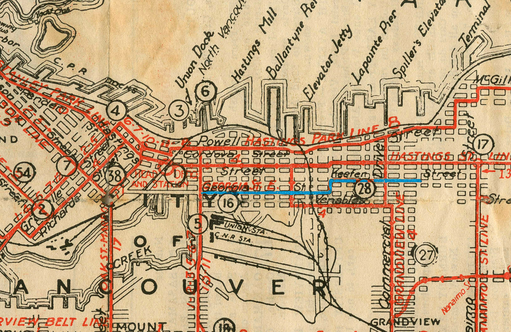
Vancouver city and suburban lines published by the BC Electric Railway Co., 1923 (crop). Photo: CoV Archives – 2011-067.1.2A strip of granite cobbles found along Frances Street in East Vancouver reveals the alignment of a former streetcar track. Starting in 1906, the “Georgia East” car travelled from Main Street to Victoria Drive via Harris Street (renamed East Georgia in 1915), Vernon Drive and Keefer Street (the latter renamed Frances Street in 1929). The “Georgia East” line was never successful. It was situated too close to the popular Hastings Line and the No. 4 Grandview Line to attract much traffic. The line finally closed in 1925 because of low ridership.

Another factor that may have led to its end was the failure of the old Georgia Viaduct to act as a streetcar connector. Built between 1913 and 1915, the Georgia-Harris Viaduct was an undertaking by the City of Vancouver to connect West Georgia Street with Harris Street at Main Street.

The viaduct would allow traffic to travel over the rail yards, CPR tracks and industrial buildings of the northeast end of False Creek. The British Columbia Electric Railway (BCER) signed a rental agreement with the city to run cars over the Viaduct in 1914. Streetcar tracks were laid in the roadway, but they were never used. By the time the viaduct opened on July 1, 1915, it seemed BCER had experienced a change of heart. They determined the project too prohibitive to undertake.

It is well-known fact in the annals of Vancouver history that the original Georgia Viaduct was a construction disaster; it was in constant repair due to subsidence issues. Occasionally, chunks would fall off the structure, terrorizing people and endangering buildings below. It’s safe to assume the structure would have been too unstable to support the continual rumbling of streetcars in addition to the constant flow of vehicular traffic. You can still see evidence of the old Georgia Viaduct streetcar tracks on a stub of the roadway just west of Main Street (next to Dalina), left after the viaduct was demolished in 1971. The photo below (left) shows the streetcar tracks embedded in the roadway today. The image on the right is from 1942, and shows what I believe is the exact same portion of roadway – notice the two grates visible in each image.

My friend, Michael Taylor-Noonan, editor of the Transit Museum Society‘s newsletter, is well versed in public transportation history. He told me that the BCER was responsible for the roadway between the tracks and roughly 18” further on each side. When tracks were lifted they had to restore the roadway. On Frances Street, it appears they replaced the rails with the narrower cobblestones seen in the photo below.

I’ve written before about historical street paving methods in Vancouver prior to the use of asphalt. In the past, hilly portions of city streets were paved with bricks or stone to allow horses’ hooves better “grip” on the sloped road surfaces. You can see evidence of this early paving practice in a few of the older areas of the city, including along a section of Frances Street near Victoria Drive. When the tracks were removed on this bricked portion of Frances Street, they were replaced with asphalt. The strip of asphalt that cuts through the centre of the brick paving is the only remaining evidence of the former streetcar alignment on this portion of the street.

Four years after the closure of the Georgia East streetcar line, the section of Keefer Street that ran between Vernon and Victoria Drives was renamed Frances Street after Frances (‘Fanny’) Dalrymple Redmond (1854-1932). “Sister Frances”, a nursing sister, was Vancouver’s first public health nurse and director of BC’s original training school for nurses. Frances Street also has the distinction of being one of only a handful of Vancouver streets named after a woman.

In his novel, All the Pretty Horses, Cormac McCarthy wrote, “Scars have the strange power to remind us that our past is real.” We should similarly appreciate urban landscape scars like those of the “Georgia East” streetcar line. These historic “scars” on our city’s landscape form part of the history of Vancouver; as such they should be shown and celebrated rather than hidden.
MAP POINTS
There are 12 comments


East Vancouver

Osteria Savio Volpe is Looking for a New Manager to Join Their Team

St. Augustine’s / Industry Apizza is Seeking a Night Kitchen Manager

Win a Trip to Guadalajara at The Tequila and Agave Festival Cocktail Competition, May 20th

Hit East Van for the 2nd Annual Vancouver Brewers Fest, April 19-28th

This Month Join Odd Society Spirits for Live Music, and an Exclusive Distillery Tour

Strange Fellows Shares New Belgian-Style, Lambic-Like Spontaneous Fermentation Beer
Popular

From Road Trip Wisdom to Laugh-Love-Language, with Bailey Hayward and Mathew Bishop

Get to Know the Gastown Izakaya Giving Vancouver’s After-Hours Scene Exactly What it Wants
Hit East Van for the 2nd Annual Vancouver Brewers Fest, April 19-28th

Ten Places to Steam, Soak and Sauna In and Around Vancouver, Mapped

Basta BBQ is Breaking the Barbecue Seal on Sunday, April 21st


Don’t miss the tracks still visible on Quebec Street between 12th and 13th Avenue. They were part of the loop which allowed streetcars to enter the Mount Pleasant Car barns on Main.
https://www.google.ca/maps/@49.2597988,-123.1031247,3a,64y,178.46h,79.96t/data=!3m6!1e1!3m4!1s1KbEUtAUcyP-aB_2UDqy-Q!2e0!7i13312!8i6656
Cool! Thanks, Graham! I am embarrassed to say that I did, in fact, miss these tracks and I live very close to them! I guess the idiom about missing things “right under your nose” is true!
You’ve solved a mystery I’ve been thinking about for years. Thanks for the knowledge!
Great article. I always talk about the Georgia/Harris streetcar line during my History Walks through the East End/Strathcona and talk about how wooden cobbles are still being dug up during road construction here and there in the city. The East Georgia tracks and their cobblestone siding were still visible near Hawks and Campbell Avenues up until the 60s and perhaps early 70s. Keep up the great work!
I am so glad I opened Scout today to read your story. Great photos and research. That’s the Vancouver history I love and cherish. Keep it coming.
Thanks everyone, I’m glad to hear you are enjoying my articles.
The BCER certainly had financial problems from the beginning. The BCER came from a receivership issue in Victoria after bridge collapsed. The operation was British owned and was transferred to Vancouver by a British lawyer by the name of Sperling. Under the new name BCER it was clear British investor Hornpayne controlled the London office. He also invested in the Canadian Northern. The arguments between the British and Canada over growth and direction were non -ending. Finally under new pre-emption law in 1920 both went into receivership. Hornpayne remained in Britain and did not live here. Both were taken over by Ottawa and Victoria. The B.C.E.R could keep the name only. Canadian Northern changed to Canadian National. From 1920 the BCER went into decline under the B.C Power corporation direction. It opened stores to sell electrical appliances and by 1955 all streetcars were gone to busses. By 1958 B.C. Hydro and Power Authority took over freight in the Valley. Buses were used call Pacific Stage Lines with money given by B.C. Hydro to operate it between Chilliwack and Vancouver.
I loved your stuff though. I thought I might add to it
Check under the south end of the Granville st bridge.Last time we looked there were tracks in the cobblestone between the first bridge pillar and you could see were a switch went off to the east.Hope they are still there.
Thanks Don, I will check that out. I think I recall what you are talking about… I used to pass by there all the time a few years ago.
Thanks to Bryan for all the inside gossip/info too!
Interesting side note- the granite stones used for retaining walls all along broadway between Rupert and renfrew streets, are old stones from the tracks. They got pulled up, and repurposed around town. Some are around the lake at Hastings park, others are in Stanley park.
Thank you for penning this utterly fascinating history of the cobblestone streets, Christine! I live on Frances Street (Franny!) just east of The Drive & am able to see these myriad reminders to a distant yet not fully buried past as I peer through my venetians at this very moment 🙂
There is still an intact section (with a switch) under the south end of the Granville Bridge. Still curious about the track scars running north of Hastings, on Victoria Drive to the waterfront, Have not been able find any information on that stretch.